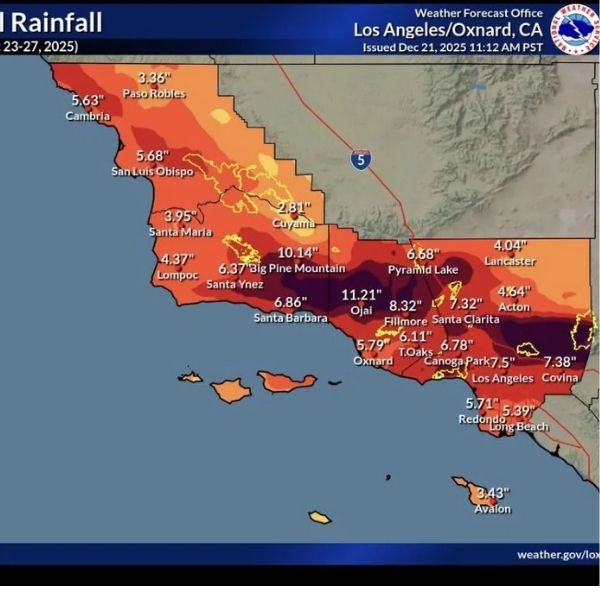
The National Weather Service updated 48-hour rainfall totals Thursday morning for the ongoing atmospheric river storm impacting Southern California. Several areas had already received half a foot of rain by Wednesday afternoon, and totals continued rising overnight, with more precipitation forecast throughout Thursday.
Some locations in the Los Angeles County foothills reported over a foot of rain, while other spots across the Southland recorded upwards of ten inches.
Los Angeles County
Metropolitan
-
Monte Nido: 3.62 in
-
Bel Air: 3.12 in
-
Big Rock Mesa: 2.99 in
-
Downtown LA: 2.66 in
-
Hollywood: 2.66 in
-
Beverly Hills: 2.64 in
San Fernando/Santa Clarita Valleys
-
Newhall: 5.98 in
-
Pacoima: 5.51 in
-
Canoga Park: 5.47 in
-
Chatsworth: 5.18 in
San Gabriel Valley
-
Eaton Dam: 4.12 in
-
Eagle Rock Reservoir: 3.78 in
-
Mt. Olive High School: 3.44 in
Mountains/foothills
-
San Gabriel Dam: 12.43 in
-
Crystal Lake: 12.13 in
-
West Fork Heliport: 7.72 in
-
Warm Springs: 6.59 in
In the L.A. County desert, Palmdale and Lancaster received 1.89 inches and 2.22 inches, respectively.
Ventura County
Coastal
-
La Conchita: 4.26 in
-
Oxnard: 4.12 in
Western Valleys
-
Matilija Dam: 8.75 in
-
Ojai: 6.70 in
Mountains
-
Old Man Mountain: 10.83 in
-
Nordhoff Ridge: 9.09 in
Orange County
Coastal
-
Coto de Caza: 2.40 in
-
Fullerton Creek: 2.21 in
Santa Ana Mountains
-
Upper Silverado Canyon: 4.68 in
-
Coldwater Canyon: 4.13 in
San Bernardino County
Valleys
-
Larson Ranch: 4.05 in
-
Glen Helen Regional Park: 3.55 in
Mountains
-
Middle Fork Lytle Creek: 12.32 in
-
Wrightwood: 9.89 in
High Desert
-
Mojave Forks Dam: 5.86 in
-
Hesperia: 2.76 in
Riverside County
Valleys
-
Temescal Fire Station: 2.64 in
-
Prado Dam: 1.74 in
Mountains
-
Mount San Jacinto: 2.99 in
-
Snow Creek Trail-Idyllwild: 2.64 in
Coachella Valley
-
Morongo Valley: 1.70 in
-
Palm Desert: 0.23 in
The NWS warns that the “long duration atmospheric river event” is not over. Additional impulses moving through the area Thursday and Friday could bring heavy showers and a slight chance of thunderstorms, with a high potential for flooding. Conditions are expected to improve by late Friday, with dry and warmer weather returning for the weekend and into the middle of next week.
This article has been carefully fact-checked by our editorial team to ensure accuracy and eliminate any misleading information. We are committed to maintaining the highest standards of integrity in our content.


Leave a Reply