
The first major hurricane threat of 2025 is heading toward land, with forecasts showing its path drifting toward the Caribbean.
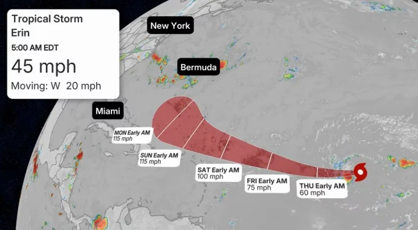
Tropical Storm Erin, now more than 1,200 miles east of the northern Leeward Islands, is expected to strengthen into a hurricane later this week as it passes near Puerto Rico, according to the Weather Channel.
From that point, predictions split. It’s still too early to pinpoint the exact track, but most models show Erin curving north into the western Atlantic, avoiding U.S. landfall. However, some forecasts indicate a more southern route, which could threaten the East Coast and eastern Canada.
By the weekend, Erin should move into warmer waters and intensify into a Category 3 storm, though it will likely remain at a safe distance. By Monday, its path should become much clearer.
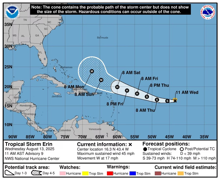
Tropical Storm Erin’s track being monitored by the National Oceanic and Atmospheric Administration shows where and when the storm could turn into a hurricane.National Oceanic and Atmospheric Administration
The 2025 Hurricane Season Is Expected to Be “Above Normal”
The National Oceanic and Atmospheric Administration (NOAA) has updated its 2025 hurricane season outlook—first released in May—reaffirming predictions for above-normal Atlantic hurricane activity through the season’s end on Nov. 30.
NOAA now estimates a 50% chance of a stronger-than-average hurricane season, down from 60% in May.
The forecast calls for 13 to 18 named storms with winds of at least 39 mph. Of these, five to nine could strengthen into hurricanes with winds of 74 mph or more, and two to five could escalate into major hurricanes with winds exceeding 111 mph.
“As we witnessed last year with significant inland flooding from hurricanes Helene and Debby, the impacts of hurricanes can reach far beyond coastal communities,” said acting NOAA Administrator Laura Grimm in a NOAA report.
A 2025 hurricane risk assessment from Cotality, a data-driven tech firm, found that more than 33.1 million residential properties—with a combined reconstruction cost value (RCV) of $11.7 trillion—face moderate or greater risk of damage from hurricane-force winds.
States with the highest number of at-risk homes and RCV include Florida, Texas, North Carolina, New Jersey, New York, and Massachusetts.
How to Prepare for a Hurricane Before It Makes Landfall
The best defense against a hurricane is a proactive plan. While you can’t eliminate all risks, taking the right steps can give you and your family greater peace of mind during hurricane season.
Start with the essentials.
“Ideally, you’d get hurricane-ready in the months leading up to the start of hurricane season on June 1st. This is when you should gather water, nonperishable foods, and a go-bag of important documents and other necessities, like cash and prescription medications,” says Rachael Gauthier, meteorologist at the Insurance Institute for Business & Home Safety in Charlotte, NC.
When a storm is forecast or approaching, insurers often issue “binding restrictions,” which halt new policy issuance or coverage increases until the danger passes. That’s why securing insurance before hurricane season begins is critical.
If you live in a hurricane-prone area, finding ideal coverage can be difficult. It’s also smart to maintain an emergency savings fund for costs your policy doesn’t cover.
“An emergency savings buffer is vital to being ready to cover unexpected costs,” advises Melanie Musson, insurance expert at Clearsurance.com. “If a hurricane rips off your siding and you’re not covered by home insurance, your emergency savings can help you recover financially.”
Plan for evacuation.
Before disaster strikes, map out evacuation routes and set meeting points inside and outside your home.
“Everyone should have an evacuation plan, since there’s always a risk you’ll have to leave your home in a hurry,” says Musson.
Fortify your home and secure safety measures.
Once a hurricane is confirmed to be approaching, shift your focus to protection.
“A few days before incoming storms, it’s a good idea to board up windows, bring in outside items that could become flying projectiles in high winds, and stock up on extra fuel for generators and/or vehicles,” says Gauthier.


Leave a Reply