
A potent atmospheric river will aim directly at the Bay Area this weekend, setting up what is expected to be the region’s wettest weekend since November of last year.
Forecasters say San Francisco could receive between 1 and 3 inches of rain by Sunday night. Instead of one intense downpour, the storm will arrive in several rounds of light to moderate rain from Friday through Monday.
How much rain ultimately falls will depend on where the atmospheric river stalls late Sunday into Monday. Even small shifts in its position could significantly affect rainfall timing and totals.
Here’s the latest timeline:
Friday: Light, steady rain with limited impacts
Rain will begin Friday morning in the North Bay, with light to steady showers developing late morning. The heaviest rain is expected between 10 a.m. and 4 p.m., producing about 0.25 to 0.5 inches.
Farther south, rain will arrive later and remain lighter. San Francisco, the East Bay, and the Peninsula should see mist and drizzle during the afternoon, followed by light showers between about 4 p.m. and 10 p.m. Rainfall totals will generally stay below a quarter inch, with higher amounts near the coast and western San Francisco. Inland East Bay areas will see less.
The South Bay will see minimal impacts. A few light showers may pass through Friday evening, but totals should remain under a tenth of an inch.
Friday night into Saturday morning: A brief lull
Rain will ease late Friday night into Saturday morning, creating the driest stretch of the weekend. However, the atmosphere will remain moisture-rich, allowing isolated showers to pop up, especially above 500 feet.
That break will be short-lived. Light rain is expected to redevelop by Saturday afternoon as the atmospheric river strengthens and refocuses on the Bay Area.
By Saturday evening, rain should become more widespread and consistent. Unlike Friday, when the North Bay saw the most rain, Saturday night’s rainfall is expected to affect much of the region.
Sunday through Monday: The main event
Sunday appears to be the wettest day of the weekend. Forecasters expect a renewed atmospheric river and a cold front to stall near the Bay Area, with additional energy from a developing surface low.
The exact placement of that low will determine where the heaviest rain falls, but conditions point to widespread rain across the region. The National Weather Service has issued a slight risk of excessive rainfall for Sunday.
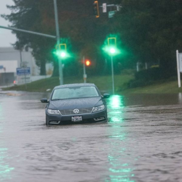
By Sunday night into Monday, impacts could increase as soils become saturated after prolonged rainfall. Periods of moderate to heavy rain could lead to localized urban and creek flooding, particularly in low-lying or poor drainage areas. Major rivers are not expected to flood, but smaller waterways could rise quickly.
By Monday morning, storm totals may reach 1 to 2 inches.
Strong winds will also develop Monday, with gusts between 30 and 45 mph possible. Wet ground combined with gusty winds could lead to downed trees and isolated power outages.
Rain will likely continue through much of Monday, though intensity may decrease compared to Sunday.
Stronger storm expected on Christmas Eve
The active pattern will continue into next week. A more powerful storm system could arrive late Tuesday and persist through Christmas, bringing heavier rain and stronger winds.
Unlike earlier systems, this storm is expected to impact much of California, delivering rain to Southern California and heavy snow to the Sierra.
This article has been carefully fact-checked by our editorial team to ensure accuracy and eliminate any misleading information. We are committed to maintaining the highest standards of integrity in our content.


Leave a Reply