
Heavy thunderstorms have unleashed chaos across California, triggering severe flooding that forced the closure of two major highways. Highways 395 and 14 remain shut down due to hazardous road conditions, leaving countless travelers stranded and scrambling for alternate routes. The closures impact thousands of motorists, raising serious safety concerns as floodwaters wash out roads and mudslides block vital transportation corridors.
Major Highways Underwater as Thunderstorms Pound the Region
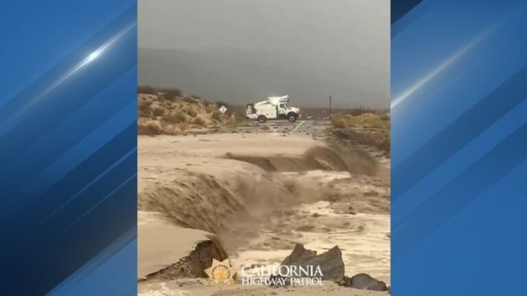
Highways 395 and 14 have turned into impassable waterways after torrential rain from powerful thunderstorms pounded the region. The California Highway Patrol (CHP) Mojave division confirmed that Highway 14 is fully closed in both directions near Jawbone Canyon, while Highway 395 has been shut down near Randsburg due to widespread flooding.
The situation escalated with alarming speed. Flash floods swept across roadways without warning, forcing some drivers to rush for higher ground. Rapid water flow washed away sections of pavement, making the roads impossible to navigate—even for emergency responders.
Although summer storms aren’t unusual in this part of California, the strength of this system caught many off guard. Authorities are now monitoring road integrity and water levels by the hour.
Road Washouts Create Dangerous Detours for Travelers
Redrock Randsburg Road, a critical link between Highway 14 and Garlock Road, has been completely washed away by floodwaters. Its destruction removed a major alternate route, complicating travel even further. Adding to the chaos, a mudslide blocked Highway 14 at Rogers Road, forcing officials to reroute northbound drivers onto eastbound Highway 58.
Travelers should brace for lengthy detours, with some reporting extra travel times of two to three hours. Crews continue to assess damage across the region as conditions shift by the hour.
Meteorologists warn that more rain could worsen the flooding in the days ahead. Longtime residents describe this as the worst flooding they’ve seen in decades, comparing it to the devastating storms of 1997.
Safety Recommendations as Recovery Timeline Remains Uncertain
While travelers eagerly await word on when these highways will reopen, officials have not released a timeline. The damage is so extensive that engineers must conduct thorough evaluations before repair work can even begin. For now, the safest option is to completely avoid the affected areas.
If travel is unavoidable, rely on real-time updates from the California Highway Patrol and local news outlets. Many stranded drivers discovered that navigation apps were providing outdated information. Always keep emergency supplies—water, food, blankets, and a fully charged phone—in your vehicle, as they could prove essential in such conditions.
Highway crews are working nonstop, but repairing the storm’s destruction won’t be quick. Even after reopening, motorists should expect reduced speeds and long-term construction along both routes.


Leave a Reply